Today, traveling from Tampa to the Pinellas peninsula is super easy: just hop in your car, zip down the highway, and cross a bridge. But before the bridges spanned the bay, traveling to the Pinellas peninsula required a boat or a very long and circuitous drive. But how many bridges cross Tampa Bay?
There are four bridges that cross Tampa Bay: the Courtney Campbell Causeway, the Howard Frankland Bridge, the Gandy Bridge, and the Sunshine Skyway. The Sunshine Skyway connects Pinellas County with the Florida Peninsula near Terra Ceia; the other three bridges connect Tampa to the Pinellas peninsula.
So can you walk across any of the bridges? Which bridge is the longest? Do you have to pay tolls? How old are they, and how long are they? You will learn more about these questions in the following sections.
The Bridges of Hillsborough County
The bridges that span the bay make life easier for the Tampa Bay area residents. Traveling between the Florida peninsula and the Pinellas peninsula would be exceedingly inconvenient without the bridges. The occasional bridge closure due to weather or an automobile accident reminds us all just how much we depend on these bridges. Let’s learn more about these incredible feats of civil engineering.
Courtney Campbell Causeway
- Length: 9.9 miles
- Deck Height: 40 feet at the apex
- Toll: None
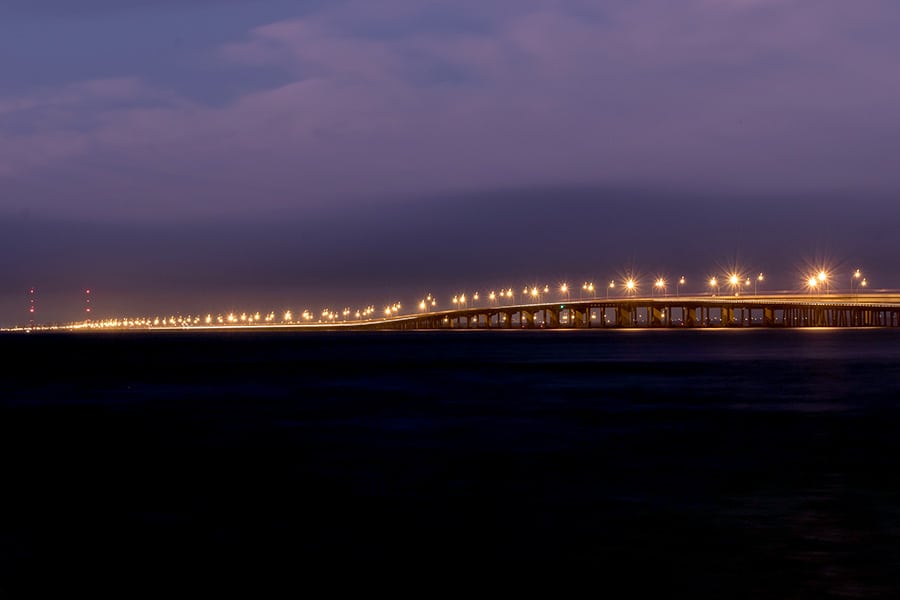
The northernmost bridge that crosses Tampa Bay is the Courtney Campbell Causeway, which carries State Road 60 between Tampa and Clearwater. A local dredging company operator named Ben T. Davis proposed the bridge in the 1920s, as it became clear that driving overland between Tampa and Clearwater – a 30-mile detour — was painfully inefficient. Davis’ dredging company was granted a contract to fill the bay, construct the causeway, and work on the bridge finished in 1934.
The causeway took a 30-mile overland route and shortened it to just under 10 miles. This route was a huge time saver for motorists. At the time of opening, drivers were charged a 25-cent toll to use the causeway, the equivalent of about $5.25 in today’s dollars. In 1944, the causeway was purchased by the federal government, which subsequently transferred ownership to the state of Florida.
Phenomenal Florida Fun Fact: The Causeway was originally named the Davis Causeway but was renamed after a Florida state senator who drove road improvement and beautification efforts along the causeway in 1948. Many people did not like this change, as they felt it replaced the legacy of the visionary Ben T. Davis with the legacy of a well-connected politician.
Today, the causeway remains a hugely popular route. It has a boat ramp and beach access on both sides, and the Tampa-side beach is named Ben T. Davis Beach in honor of the man who envisioned the bridge.
The causeway also has a trail that allows bicyclists and pedestrians to stroll or cycle across the bay. Best of all, the toll vanished over the years, meaning you can now drive the causeway without having to pay.
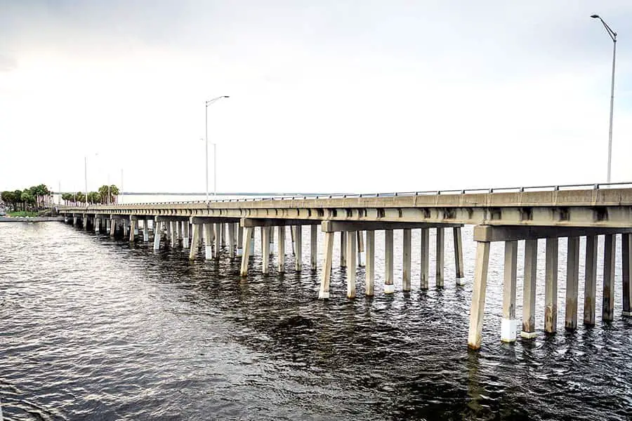
Howard Frankland Bridge
- Length: Approximately 3 miles
- Deck Height: 43 feet northbound; 48 feet southbound
- Toll: None
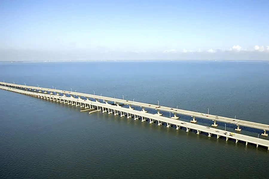
Continuing south, we come to the Howard Frankland Bridge. Named after a famous businessman who proposed the bridge, the Howard Frankland connects the notoriously busy Interstate 275 from Tampa to St. Petersburg, making it the most traveled bridge across the bay. Currently, the Howard Frankland has four lanes of traffic in each direction for a total of eight lanes and runs approximately three miles end-to-end.
The Howard Frankland has a colorful history. When it first opened in 1960, it only had four lanes in total. It was also built to dubious standards and did not have any emergency shoulders; furthermore, the median separating northbound and southbound traffic was substandard. Because of this, the bridge was often the site of grisly motor vehicle accidents, and citizens eventually demanded improvements to the bridge.
Eventually, the DOT decided to expand the bridge by building a new four-lane span parallel to the existing bridge. The original bridge is now the northbound span, with all four lanes running in one direction. The southbound span, completed in 1990, is slightly longer and has a slightly lower deck height than the northbound span.
While the bridge itself is not undergoing active construction, the Florida Department of Transportation continues to improve the feeder roads on both ends of the bridge. This process will continue into the foreseeable future.
NOTE: While the Florida Highway Patrol does patrol the bridge, some drivers view it as a speedway. Aggressive driving is common on the bridge. Many local street racers also use it for street racing. Be alert and drive defensively when crossing this bridge.
Other Posts of Interest
- Which Side of Sanibel Island Is The Best?
- What Is Treasure Island, Florida Known For?
- Do Both Alligators And Crocodiles Live In Florida?
- What Is The Biggest Shipping Port In Florida?
Gandy Bridge
- Length: Approximately 3 miles
- Deck Height: 43 feet
- Toll: None on the bridge. Connector to Selmon Expressway is $0.95 with SunPass and $1.35 with toll-by-plate.
The southernmost bridge that connects Tampa to St. Pete is the Gandy Bridge, which locals call The Gandy. The Gandy has undergone quite an evolution over the years; the current bridge does not contain any components of the original bridge.
The original Gandy was dreamed up in 1910 by businessman George Gandy and his partner Walter Fuller, both of whom wanted a convenient way to get from St. Pete to Tampa.
World War I derailed Gandy’s plans for a time, but in 1922, he again promoted his idea. As a result, the bridge was constructed over two years and opened to traffic in 1924, running 2.5 miles with a deck height of 75 feet and featuring a draw bridge.
By 1947, the bridge was outdated. Like with the Howard Frankland, a second span was constructed alongside the first. The second span opened in 1956 and served westbound traffic, while the original span served eastbound traffic.
However, the ravages of time and the chronic underfunding of DOT upkeep efforts led to the gradual degradation of these spans. Finally, in 1975, a third span was opened, and the original span was demolished.
In 1996, a fourth span was opened, and the second was closed. Citizen groups wanted to keep the second span open as a trail for walkers and bikers, but inspection by civil engineers revealed that the bridge was completely unsafe for any kind of traffic, and it was eventually destroyed.
As if all that wasn’t enough, plans are in the works to eventually replace the third span with a new span and convert the fourth span into a pedestrian trail. Time will tell how that project unfolds.
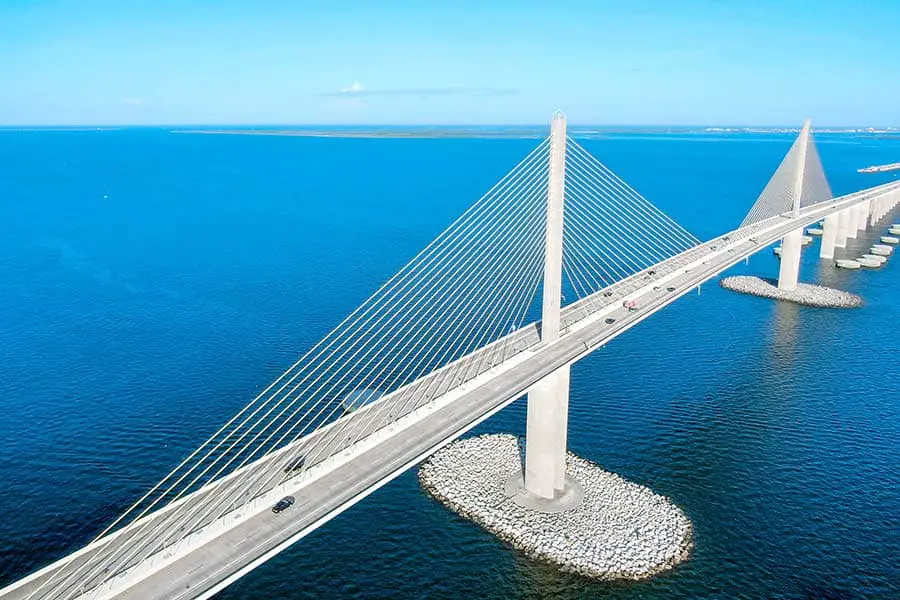
Sunshine Skyway
- Length: 4.14 miles
- Deck Height: 190 feet
- Toll: $1.07 with SunPass, $1.50 toll-by-plate
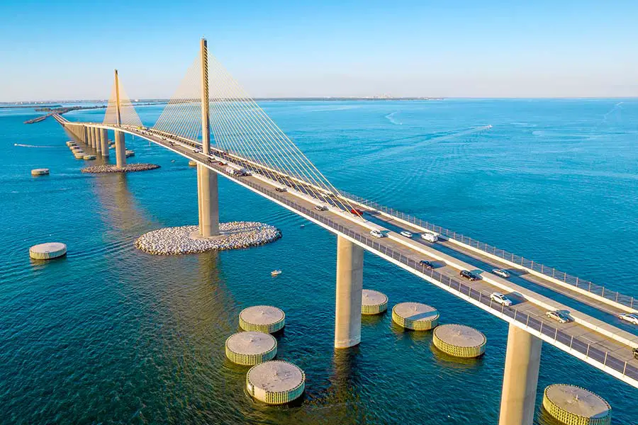
A fourth bridge spans Tampa Bay, although it does not connect to Tampa. The Sunshine Skyway Bridge connects St. Pete to Terra Ceia. It is a much taller bridge than the others, with a deck height of 190 feet and a total span of 4.14 miles!
The Sunshine Skyway opened in 1954 to great acclaim. The original bridge sat 150 feet above the bay and had two lanes of traffic; it was expanded in 1969 with a second span that opened to traffic in 1971. The following nine years were mostly uneventful, but 1980 brought tragedy to the Skyway.
On January 28, 1980, the U.S. Coast Guard cutter Blackthorn collided with a tanker called the Capricorn near the Skyway, resulting in the death of 23 crewmen on the Blackthorn. Then, on May 9 of 1980, a cargo vessel called the MV Summit Venture plowed into one of the bridge’s support columns, which caused the southbound span of the bridge to collapse, killing 35 people.
With the southbound span collapsed, it became evident that building a brand-new bridge would be easier than repairing the old bridge. After much debate, the design for the new Skyway was approved, and construction began in June of 1982.
The new bridge opened in 1987, and its unique and beautiful appearance made it an instant icon. The graceful arch of the bridge, encompassed by two tall pylons and a series of cables, creates a striking and modern look. Colorful lighting along the pylons and cables makes the bridge a spectacular sight to see at night. The Skyway is a feat of engineering and a thrill to drive across.
Can You Walk Across Any of the Tampa Bay Bridges?
Head to the Courtney Campbell Causeway if you want to walk across Tampa Bay. You can park your vehicle on either side and take the Courtney Campbell Trail across the bay, either on foot or on a bicycle. Keep your eyes open: you might see dolphins in the water.
Pedestrian traffic is not allowed on any of the other Tampa Bay bridges.
What is the Longest Bridge in Tampa, Florida?
At 9.9 miles from end-to-end, the Courtney Campbell Causeway is the longest bridge in Tampa. The Gandy and the Howard Frankland bridges are both approximately three miles long, which is an impressive span but not enough to unseat the causeway’s position as the longest bridge.
Cross That Bridge
Tampa Bay is a beautiful body of water, but it makes getting from the Pinellas peninsula to mainland Florida rather inconvenient. Fortunately for modern Floridians, those who came before us thought about the future and took action to bridge the bay.
Tampa Bay citizens can now enjoy easy and convenient trips across the water without needing a ferry. As Tampa Bay continues to grow and evolve, the bridges of Hillsborough County continue to be a vital part of our local infrastructure and will likely be fixtures in the Tampa Bay area for decades to come.